|
by John C. Evanoff
July, 2005
If you want to view Reno, Sparks,
Carson City, Washoe Lake, Geiger Grade, Tahoe, Truckee, Boca, Prosser,
Stampede, Verdi, Dog Valley, Peavine Mountain, Spanish Springs,
as far north as Palomino Valley and as far south as Gardnerville
and the Jobes Peaks, you must try hiking the trail to the top of
Mount Rose and Slide Mountain. Both trails offer breathtaking views
and Mount Rose is especially wonderful from July through September.
Both trails can be reached by taking
the Mount Rose Highway, State Route 431, nine miles west of Highway
395 South and the Mount Rose Trail is also part of the Tahoe Rim
Trail which encircles the entire lake for more than 165 miles. The
pass is more than 8,900 feet and just a hundred feet past the summit
you will find a road to the left to Mount Rose campground. The campground
is only open a few months of the year in late summer and early fall,
but it attracts day hikers who wish the benefit of an overnight
stay between hikes in the area. The high end of the campground is
the start of the Slide Mountain trail which follows a road to the
top where several television and radio towers exist. It's a short
and easy trail up a utility road and the views are special from
the top. The back of the mountain has several small trails used
by skiers in the winter leading back to the campground and accessing
the Tahoe Meadows area to the west.
At Tahoe Meadows, there is a parking
area and entrance to the Tahoe Rim Trail whole access trail, a one
mile trail built and maintained by the Tahoe Rim Trail organization
for day hikers and folks who may only be able to handle a light
trail hike but having plenty of things to view and experience. My
wife and I helped build a portion of this trail as crew leaders
and trail building members back in 1996 and 1997. It is wide enough
for a wheelchair and is easily accessible from the roadway.
The Mount Rose trailhead begins at 8,800 feet just past a snow-plow
maintenance shed on the right side of the highway going west down
into Tahoe Meadows and Incline Village. Parking is along the side
of the road or across the highway a bit further down the road at
the Tahoe Meadows entrance. This trail climb is about four to six
hours in duration depending on your level of hiking competence and
endurance and is rated as moderate to difficult. At over 10,776
feet in elevation and a trail with 1,900 feet of vertical gain measuring
over six miles, you should bring plenty of water and a back pack.
Include a camera, binoculars, first aid kit, lunch and snacks, a
wind breaker, extra socks, number 30+ sunscreen, additional water
and a pencil and note book. The note book is to jot down your thoughts
of the great vistas, geography and wildlife experiences you encounter.
Leave all other valuables in your car trunk.
The first mile gives you a visual
of Tahoe Meadows and Lake Tahoe's Incline Village area. The road
is wide and an easy walk. You'll encounter mountain bikers and other
hikers all along the roadway to the Mt. Rose Trail. Most of the
trees along the first two miles are Ponderosa, Sugar Pine, Jeffery
Pine, White Pine, Aspen and Lodge pole. Lupine, sagebrush, Mules
Ear, paintbrush, larkspur, bluebells, willows and assorted high
sierra wildflowers line the road and trail all the way to the timberline
at around 10,000 feet. A small pond to the left at about the two
and a half mile mark and just before the Mt. Rose trail is called
Frog Lake. It's a favorite stop for picnics, camera shots and a
quick rest. The road goes on to the relay towers and to Rose Knob
Peak and Rose Knob which is another great hike. The Mt. Rose Trail
is marked on the right by a small Forest Service sign. This trail
leads over a small hill into the top end of Galena Canyon. You then
venture down hill before reaching a creek running to the north where
you will then begin the ascent to the top. This trail zigzags much
of the way and you should pause to enjoy the spectacular views and
wildlife including squirrel, marmot, mule deer, chipmunk, Clark's
nutcracker, blue jay, woodpecker, mountain quail, snow partridge,
goshawk, falcon, golden eagle and vulture. You may also see a few
hang gliders and paragliders because of the great thermals in the
area. Many glider pilots from Truckee and Minden also use the thermals
around Mount Rose to gain the best altitude in the entire Tahoe
region. At the ridgeline, another trail heads down into a long valley
heading north to Verdi. That hike is much longer and should be attempted
over the course of an entire day or two. The ascent to the top from
the ridgeline continues through switchbacks and once on top of Mount
Rose, you will have the opportunity for some great picture taking
and binocular views of North Western Nevada, North Eastern California
and all of Lake Tahoe. The rock shelters at the top are sometimes
inhabited by overnighters who like to take in the night sky for
some great astronomical viewing. Many decades ago, a scientist named
Church used the area as an amateur observatory and was known to
hike every weekend with his telescope to the top of both Mt. Rose
and Slide Mountain to acquire views of astronomical objects. A pond
half way up Galena Canyon is named after him and an historical sign
notes his observation area at the SR431 roadway summit.
A logbook is usually kept at the
Mt. Rose summit site and gives you an opportunity to write your
name and opinion of the tremendous views. Past years logs are kept
at the Carson City Ranger Station. This is also a chance to take
an hour or two to breathe in the high altitude and spectacular scenery.
You can see to the east to Geiger Grade and SR431 meandering its
way up the hill towards you. To the south east you can see Washoe
Lake, the top of Slide Mountain, the Mount Rose Ski Area, Carson
City, Minden and Gardnerville. To the south, you can see the Marlette
Lake and Hobart Reservoir area and all the way to Jobes Peak and
Jobes Sister. On clear days, you can see the peaks above and to
the southwest of Bridgeport. To the west, you can view almost all
of Tahoe, Brockway Summit, Mt. Baldy, Rifle Peak, Rose Knob Peak,
Rose Knob, Martis Peak, Truckee, Boca, Prosser and Stampede Reservoirs,
Highway 80 West and the Donner Lake area and Donner Summit. Northwest
you will see Dog Valley, Peavine, Verdi Peak and on a clear day
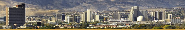
the top of Shasta Mountain. North you can see all of Reno, Sparks,
the North Valleys, Red Rock, Sun Valley, Spanish Springs and the
mountains encircling Pyramid Lake. A good set of binoculars afford
you a better view of the entire area. And of course, a camera is
a must if you want to show your friends the trail and views. The
winds at the summit can be treacherous at times reaching speeds
of more than seventy miles an hour. The rock shelters will afford
you protection if those conditions exist. This is a great time to
relax before the walk back downhill. Take your time walking back
to the parking area so you can refresh your memory of the adventure
up to the summit and view the surrounding forest and Lake Tahoe
in all its majesty.
Wear good hiking boots and be prepared
for sudden storms. I remember one hike to the top on my 50th birthday
in October 1997, when storm clouds surrounded the mountain. I reached
the summit with no problem but the darkening skies moved me to make
my stop brief. Within minutes of beginning my descent, the thunder
and lightning rolled in and it began to snow. Exciting as it was,
I believe myself lucky not to be hit by lightning or stuck overnight
in the snow. I made it back to my vehicle in a record one and a
half hours from the top. Four inches of snow fell before I reached
the car and I was soaking wet by the time I got my backpack off.
But, I think you will agree, this hike is definitely a must if you
enjoy great vistas and a day to remember.
All these trails are in a protected
area of Forest Service land in the Toiyabe National Forest called
the Mount Rose Wilderness Area. So be sure to pack out your trash
and stay on the trail to protect plants and wildlife.
The Tahoe Rim Trail Association
is a volunteer, non-profit organization established in 1981 to construct
and maintain the 165 mile trail. The trail is open to hiking, equestrians
and mountain biking. Mountain Bikers can use the Tahoe Rim Trail
on most of its length, but it is important to note that some areas
around Tahoe are protected, including parts of the Mount Rose Wilderness
Area. Call the Carson City Nevada Forest Ranger Station for more
information on these and other trails in Western Nevada. |